


Who Wants a Good Bike Map for Ottawa-Gatineau?
It's time for an upgrade, and what we need is probably not coming from City Hall.

Finding new bike routes
The Ottawa-Gatineau bike network is growing all the time. But there is remarkably little effort made to tell people about new bike infrastructure.
So if you want to cycle somewhere new, how can you find safe biking routes?
I’ll talk about a few options but first, please share your thoughts on the following question:
1. Google Maps
Google Maps is not particularly well designed for bike travel in Ottawa-Gatineau (and Apple Maps doesn’t offer bike options here yet).
Google often suggests routes that seem to be geared to “strong and fearless” cyclists — who amount to about 5% of the population. Not so great for the rest of us.
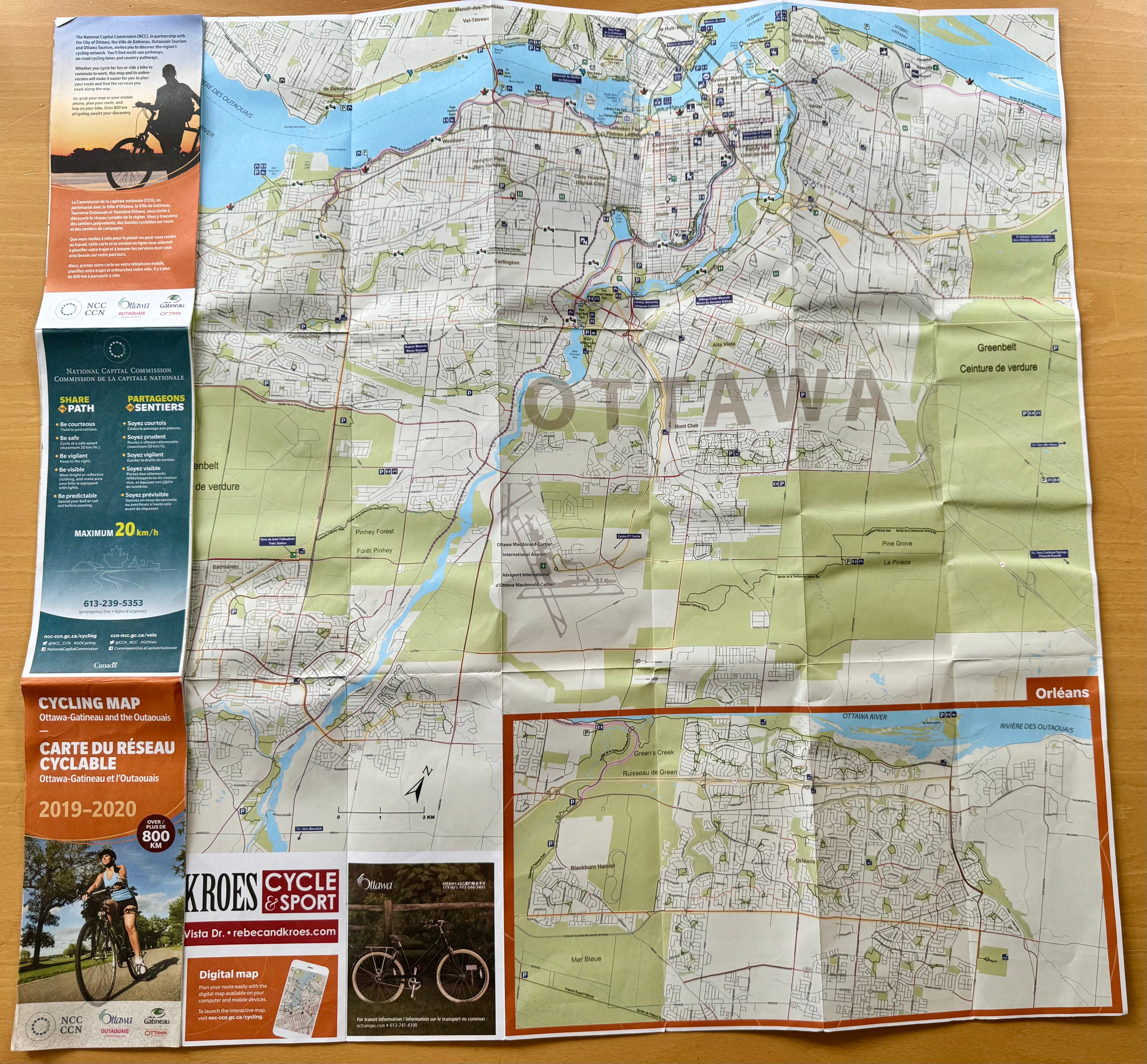
2. Official Ottawa-Gatineau cycling map
Ottawa and Gatineau, along with their tourist agencies and the NCC, jointly produce a map with cycling routes in the region.
It’s available online as an interactive map.
It’s also available as a printed map, but that was last done for 2019-20 so it’s getting a little long in the tooth. The City of Ottawa has only the 2018 version on its website. The City of Gatineau has a 2023 map, but it is only for the Gatineau side. In both cases, these are big PDFs, so not useable when out riding.
Whether online or in print, it’s a map that tries to do too much. Protected bike lanes and multi-use pathways — yes. Paved shoulders and suggested connector routes — not so useful; they just create the illusion that there will be safe connections out there.
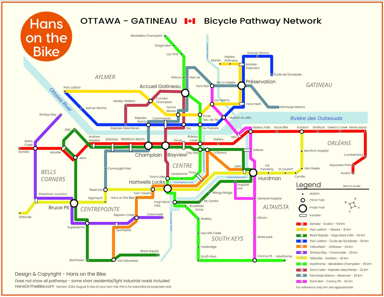
3. Community-produced maps
Hans on the Bike has a metro-style map of the multi-use pathways in Ottawa. This is useful for planning, and even knowledge cyclists will find routes they didn’t know. This map is a little harder to use in the wild — these station names don’t exist out there and sometimes the connections are less obvious than others.
Bike Ottawa has generated local bike maps, although they may currently be looking for a volunteer to maintain and advance that work. Those maps vary in terms of their usability. The winter cycling map is very good, and fully useable on a phone.
What’s missing
In Ottawa-Gatineau, we need a map for people on the go. A map that is:
Easy to use on a phone
Live showing your current location, rather than a static PDF file
Focused on showing only the protected infrastructure and bike lanes — and not a lot of extraneous information that clutters the screen
Able to show the full network, or just the All Ages and Abilities routes
The online official Ottawa-Gatineau map is live, but doesn’t meet the other success criteria.
Is there interest out there?
I have previously created such a map and had made it publicly available; but let it expire due to the platform costs.
If it is of value to others, I’d be ready to bring that back.
If you would find useful a map of the Ottawa-Gatineau bike network that you can use on your phone in real time, let me know — through the poll above, or in the comments.
I’ve been noodling on a way to collect better data to map out bike routes and visualize the unofficial connections between designated bike paths. Kind of like what Mexico City did to map their unofficial public transit system (see Mapatón / Gabriella Gómez-Mont), except it would have to be usable while cycling.
Perhaps a GPS device attached to handlebars, with a button that the cyclist presses if they notice an issue - i.e. bike path ends suddenly, feels unsafe, lack of signage, poorly lit. Over time we’d get a sort of heat map that could inform a cycling master plan and future upgrades/investment.
Could also do a more passive version using phones for the location data, but I like the nuance of being able to see not only where the paths are but how the paths feel.
It is such a pain to try to find routes to places I’ve never been to. There needs to be a simple, preferably free, app that lets you navigate much the way google maps lets you do that for driving.